
www.agritechmag.com
20
'26
Written on Modified on
Agricultural Data Pipelines for Field-Level Supply Chain Intelligence
Regrow introduces its Ag-gentic AI agent platform to automate multi-source agronomic data integration for scalable environmental modeling.
www.regrow.ag
Aggregating disparate agronomic records across global food supply chains poses severe operational hurdles due to conflicting spatial resolutions, irregular temporal frequencies, and fragmented data schemas. To resolve data engineering bottlenecks before environmental modeling can begin, autonomous data architectures use software agents to standardize complex earth observation, meteorological, and ground records across global agriculture, consumer packaged goods, and financial underwriting sectors.
Regrow introduced Ag-gentic, an autonomous artificial intelligence agent platform engineered to construct, execute, and maintain complex agronomic data integration pipelines. The company developed the system to automate data plumbing across its Agriculture Resilience Platform and commercial application programming interfaces, providing scalable, field-level environmental intelligence for food manufacturers, agribusinesses, and agricultural lenders without requiring manual data pipeline engineering.
Architectural Principles of the Autonomous Agent Pipeline
Traditional data architectures often require extensive human oversight to handle edge cases, missing geospatial tiles, and format misalignments. Ag-gentic replaces manual extract, transform, and load workflows with an agentic architecture built on four deterministic engineering principles. Each step within a pipeline performs a single, isolated function with explicitly documented inputs and outputs, allowing an agent to reason about task dependencies autonomously.
Pipeline steps incorporate self-checking mechanisms to validate output completeness and flag schema anomalies before raw data flows to downstream environmental models. Furthermore, execution tasks are designed to be idempotent and safe to re-run, enabling an agent to resume interrupted processes without duplicating data or corrupting existing tables if an upstream application programming interface times out. The architecture also calculates compute resource expenditures prior to pipeline execution, providing predictable infrastructure cost forecasting for large-scale geospatial queries. Over a six-month deployment phase, the platform codebase integrated more than 105 agent-authored pull requests subject to internal scientific auditing.
Harmonized Geospatial Records and Yield Resilience Modeling
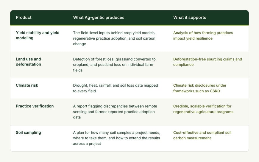
The platform consolidates disparate data streams into a single standardized record for every field and growing season. By ingesting earth observation satellite imagery, local weather grids, soil characteristic databases, drought monitoring layers, and farmer-reported operational logs into a unified structure, the system eliminates cross-model discrepancies between carbon accounting, deforestation verification, and crop yield models.
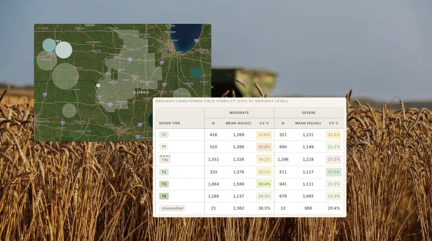
In a technical deployment evaluating the relationship between regenerative agricultural practices and crop yield stability during drought conditions, the platform automated the fusion of more than 20 independent geospatial and agronomic layers. The computational redesign reduced processing expenditures for a nationwide agricultural data layer by approximately sixtyfold. The resulting dataset supported a multi-layered analysis covering approximately 152,000 crop cycles within a single quarter, tracking the correlation between soil carbon levels, management practices, and harvest outcomes across regional supply sheds.
Additional Context:
This section details technical specifications and competitive benchmarking not included in the original product announcement.
Agronomic environmental intelligence platforms operate within an ecosystem dominated by specialized measurement, reporting, and verification providers alongside geospatial analytics engines such as Indigo Ag, EarthDaily Agro, and the European Space Agency’s Copernicus data access services. A primary industry challenge lies in harmonizing optical satellite observations—such as European Space Agency Sentinel-2 10-meter to 20-meter multispectral bands and NASA/USGS Landsat 8 and 9 30-meter thermal and multispectral sensors—with cloud-masking algorithms like s2cloudless and interpolated gridded meteorological data from ECMWF ERA5 or NOAA PRISM.
Standard industry data processing traditionally relies on orchestrated workflow engines such as Apache Airflow, Prefect, or Dagster, which mandate predefined Directed Acyclic Graphs that require manual developer reconfiguration whenever upstream data structures or spatial bounding coordinates shift. Benchmarked against deterministic workflow orchestrators, autonomous agent frameworks utilize large language models to dynamically construct sub-pipelines, evaluate output validation schemas conforming to Open Geospatial Consortium standards, and correct spatial datum mismatches without continuous human engineering interventions.
Edited by Natania Lyngdoh, Induportals editor, with AI assistance.
www.regrow.com
